

MARINE MAGNETICS SEA SPY MAGNETOMETER 1000 METER
RUGGED
Smart connector
The SeaSPY connector is a custom brass underwater connector that supports a tonne of towing force. A PVC nose cone protects it from side impacts, while maintaining a streamlined tow body.
Sleek Design
SeaSPY’s sleek design resists snags. The inexpensive and ïeld replaceable tailïns are the only protruding element and they are designed to snap off should they ever get snagged on rocky outcroppings.
Reliability
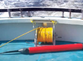
The SeaSPY towïsh is made of 1⁄4” super strong ïberglass coated with a ‘bumper’ layer of polyurethane for extra shock absorption. Should even a drop of water penetrate the towïsh, a leak detector warning appears on your screen to inform you. In the event of a breach, the SeaSPY’s electronics module is encased in a polycarbonate housing with ‘O’ ring seals for another layer of security. The sensor itself is suspended on shockmounts to ensure the quality of your data isn’t inïuenced even if you drag SeaSPY along the sea ïoor.
A quick glance self diagnostic LED system on the isolation transceiver can save hours of frustration. If all connections are hooked up properly, a status LED will glow green. If there’s a problem with one of the connections, it will glow yellow. If there’s a short somewhere, it will glow red and the transceiver will safely shut down the output power in microseconds. A blue LED ïashes with every mag reading.
Better Data
Worldwide Operation with No Restrictions
SeaSPY will collect accurate data no matter where you are or in which direction you are surveying.
Highest Absolute Accuracy
SeaSPY Overhauser sensors have the highest absolute accuracy of any magnetometer: 0.1nT. The repeatability between SeaSPY sensors is also unmatched at better than 0.01nT.
The beneïts to the user are four-fold
1. Targets will not be missed because they fall between mismatched survey lines.
2. Reduces post-processing. Competing technologies require the user to collect tie lines in order to level the data set (match-up inaccurate survey lines).
3. There will be no variation introduced in the data by slight course changes during a survey line.
4. A magnetic map of an area will look the same, regardless of direction in which the survey lines were conducted.
Download files

Take advantage of over 50 years of experience from our sales team.
02/27/2024

- Read More...
- Read More...